The Rocky Mountain Map Society is a non-profit organization dedicated to the study and appreciation of maps and other items of cartographic interest. The Society was formed in 1991 and is based in Denver, Colorado. Upcoming meetings, past events and other information can be found at the tabs above. We hope to see you soon!
Announcements:
-
RMMS Lecture Openings
-
We have some open slots in our 2026 lecture schedule. If you are interested in giving a talk, or know someone who would be a good fit, please contact Vincent.louis.szilagyi@gmail.com. Any and all map related topics are welcome, as are any level of speaker experience. Thank you!
-
-
"Boulder County Centennial Farms"
-
Tuesday, June 23, 2026 @ 5:30 PM MT, History Colorado, Downtown Denver
-
This discussion covers Linda’s project “Gone, But Not Forgotten,” a Boulder County Centennial Farm Documentary featuring photographs and stories from still-operating Centennial Farms. It includes 1880s maps, such as Drumm's, original land ownership details, and accounts of the women who kept these farms in their families for over a century.
-
She is a professional jeweler and fine art documentary photographer. With 50 years in the field, she served as a board member for artists’ groups, managed galleries, curated over 1,000 exhibitions, and exhibited her jewelry and photography both nationally and internationally.
-
Linda has authored documentary projects such as “Guided by Angels,” a book about finding her birth family in the 1980s. She founded Denver's first arts fund for homeless individuals, “We are all in this together,” and documented “Working Women” through workplace photography.
-
Note: This talk will be in person and over Zoom (link here)
-
Registration required (free) for in person attendance (please click here)
History Colorado Center, downtown Denver. Please click here for parking information. Program will be in the Martin Room, on the 4th floor. Please enter the building at the main (front) entrance.
-
-
New Feature in Colorado Magazine: “Lost and Found – Rediscovering Colorado’s Earliest Records” by RMMS member Larry Obermesik
-
We’re excited to share an engaging piece from Colorado magazine titled “Lost and Found: How my pandemic pastime led me to rediscover some of Colorado’s earliest records.” Over the course of the pandemic, RMMS member Larry Obermesik turned a quiet hobby into a remarkable journey through archives, unearthing forgotten maps, journals, and documents that shed new light on the early days of Colorado’s settlement.
-
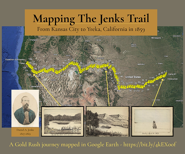
You may remember that Larry presented the story to RMMS last year of Daniel Jenks, the early Colorado gold miner, from the journal Larry discovered in the Library of Congress. Larry has gone on to do amazing research on the Jenks family and uncovered important documents of broader importance to share with other researchers.
-
-
A Mistake Map: Did putting El Paso in the wrong spot cost the US 10 million dollars? An article by Shaun Boyd
-
Karen Pinto, a scholar in the history of Islamic cartography, has a collection of maps on Pixeum.
-
Curtis Bird has YouTube interviews with various map makers (link)
-
Time Traveler's Map of Denver (link) - A site to compare historic maps of Denver with the current map.
-
Follow the Rocky Mountain Map Society on Facebook.
-
The Rocky Mountain Map Society has a YouTube Page now! Past talks are available to view whenever you like. Check it out!
-
The publications by RMMS Members page has recently been updated.
-
Our friend John Docktor has a wonderful list of all upcoming map events, not just in the USA, but across the pond as well. Please check it out!
-
RMMS is collaborating with outstanding map societies across the country for some Zoom meetings! Check out their websites!